Find content
#615774The Munns Report
 Posted by on 01 August 2012 - 04:46 PM
The only filmed release of this expedition will be as part of the BLUFF CREEK FILM SITE PROJECT. Those should appear in late summer or early fall. Drop that title into YouTube if you haven't seen our videos. This was a fully independent, non-commercial and unbiased labor of love for all of us. Before there was "Finding Bigfoot" there were two guys named Cliff and Bobo, and they were friends of mine. They helped me by confirming things that they knew about the site, such as that Gimlin had tentatively identified the general location back in 2003. Daniel Perez, of course, has always been a great resource on history for me. We did the best we could with our experience and local expertise to find and document the site and validate or refute aspects of the claims about the history of Bigfoot in Bluff Creek. We wanted those who had helped us along the way to be there, and we also wanted those who could with their own expertise take it farther than we could to the next step. Having Bill Munns come up there with us occurred to us as a natural idea way back in 2009, and it was quite a glorious day when he finally made it there and got to see the Big Trees on the true film site. Now the data is in his hands, as well as a geologist who is doing independent surveying analysis on the site, and our own work is essentially done. I know already that Bill is the right guy for the job going forward, and from his work we should at last have reliable information about the action and subject seen in the Patterson-Gimlin Film.
This link will sort BLUFF CREEK FILM SITE PROJECT by most recent videos first, for those who are interested. Just scroll down past the Coast to Coast AM links to find them.
http://www.youtube.c...o_date_uploaded
More info covering the whole "re-discovery" process may be found on my blog, of course (bigfootbooksblog.blogspot.com)
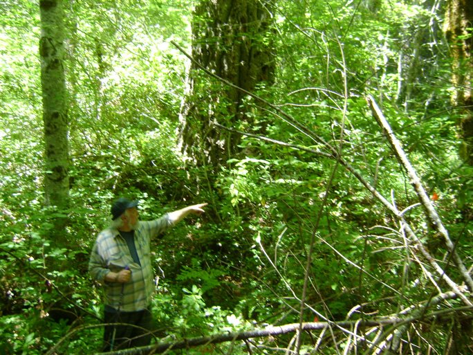
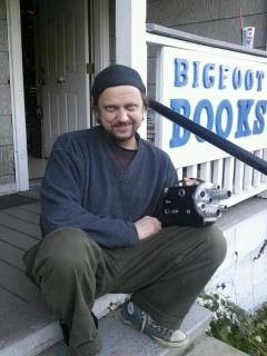
Here is an image of Bill just after he first saw the Big Tree, and then started pointing out the others seen in the background of the PGF.
Click to Enlarge
Best,
Steve/BFBM
http://bigfootbooksblog.blogspot.com/
This link will sort BLUFF CREEK FILM SITE PROJECT by most recent videos first, for those who are interested. Just scroll down past the Coast to Coast AM links to find them.
http://www.youtube.c...o_date_uploaded
More info covering the whole "re-discovery" process may be found on my blog, of course (bigfootbooksblog.blogspot.com)
Here is an image of Bill just after he first saw the Big Tree, and then started pointing out the others seen in the background of the PGF.

Click to Enlarge
Best,
Steve/BFBM
http://bigfootbooksblog.blogspot.com/
#615047The Munns Report
Posted by on 30 July 2012 - 05:59 PM
Bill, it was truly a great thing to have you come to the film site. I hope that the data we all retrieved will advance your cause, and lead to real knowledge (at last) about the PGF and its subject as it moved through the site. Having you, Daniel Perez, and the others come up and join us in the BLUFF CREEK FILM SITE PROJECT was truly an honor. We very much look forward to your results.
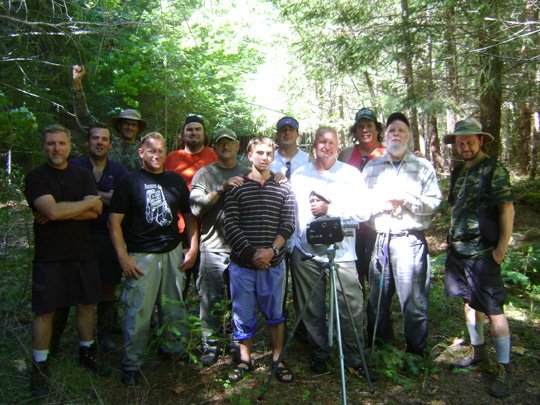
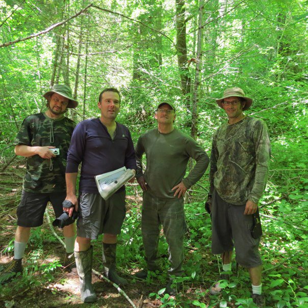
I'll have more photos and information on my blog soon, but for now here is a group photo from down in Louse Camp.

Back row: Todd Hale, Tom Yamarone, Steven Streufert, Ian C., Daniel Perez, Rowdy Kelley, Terry Smith, Scott McClean, Cliff Barackman
Front row: James Bobo Fay, Francis and Robert Leiterman, Bill Munns
Foreground: Monkey and Pre
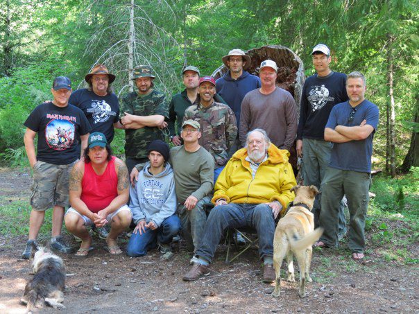
Here is another, on the site right on the trackway, to include all members...
Cliff Barackman, Ian C., Rowdy Kelley, Todd Hale, Jamie Snowhorse, Robert and Francis Leiterman, Bart Cutino, Terry Smith, James Bobo Fay, Bill Munns and myself.
(Missing Richard L., the retired USFS hydrologist who joined us the first day, and Scott and Tom who stayed in camp.)
Here are the original BLUFF CREEK FILM SITE PROJECT guys, reunited with Ian's return...

Steve, Ian, Robert and Rowdy, in front of the Big Trees.
Images will enlarge if clicked.
Best regards,
BFBM
Steven Streufert
http://bigfootbooksblog.blogspot.com/
I'll have more photos and information on my blog soon, but for now here is a group photo from down in Louse Camp.
Back row: Todd Hale, Tom Yamarone, Steven Streufert, Ian C., Daniel Perez, Rowdy Kelley, Terry Smith, Scott McClean, Cliff Barackman
Front row: James Bobo Fay, Francis and Robert Leiterman, Bill Munns
Foreground: Monkey and Pre
Here is another, on the site right on the trackway, to include all members...

Cliff Barackman, Ian C., Rowdy Kelley, Todd Hale, Jamie Snowhorse, Robert and Francis Leiterman, Bart Cutino, Terry Smith, James Bobo Fay, Bill Munns and myself.
(Missing Richard L., the retired USFS hydrologist who joined us the first day, and Scott and Tom who stayed in camp.)
Here are the original BLUFF CREEK FILM SITE PROJECT guys, reunited with Ian's return...
Steve, Ian, Robert and Rowdy, in front of the Big Trees.
Images will enlarge if clicked.
Best regards,
BFBM
Steven Streufert
http://bigfootbooksblog.blogspot.com/
#596543The Munns Report
Posted by on 03 June 2012 - 04:58 PM
Thank you, Bill.
I certainly do not wish to violate the rules of this Forum.
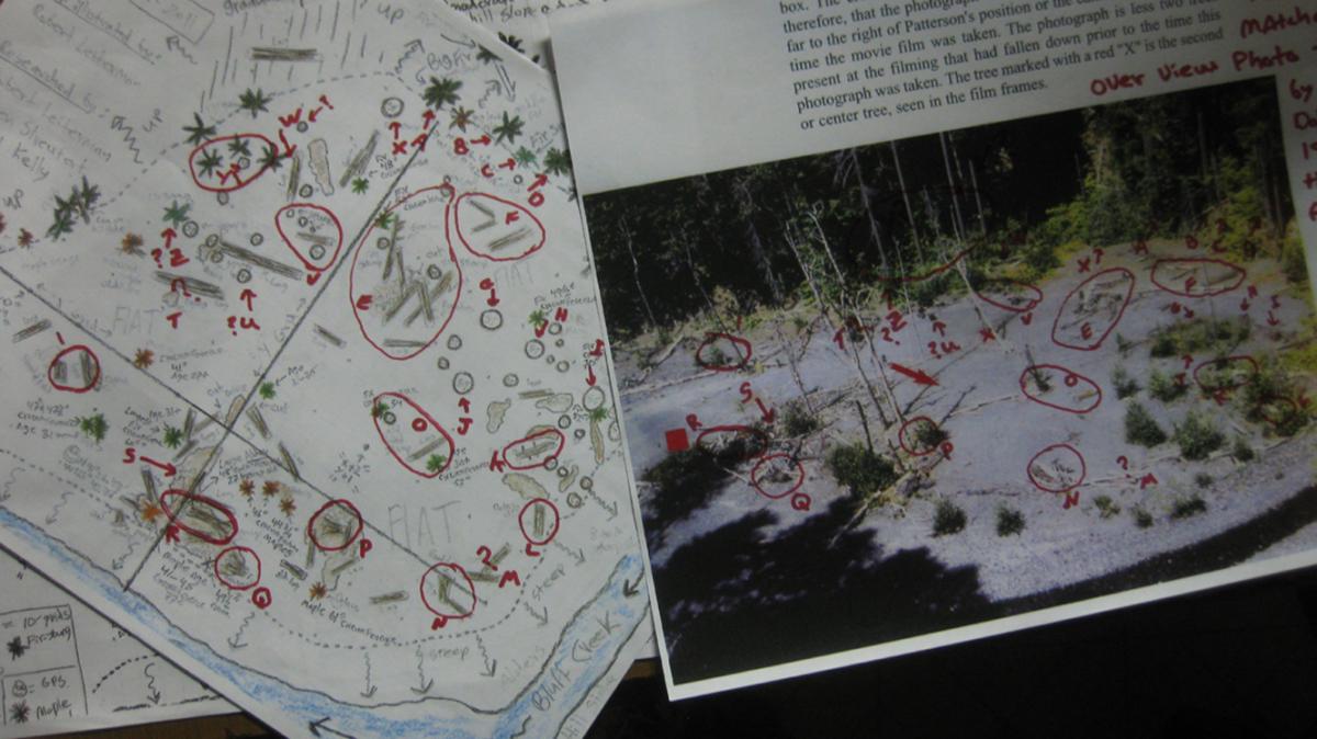
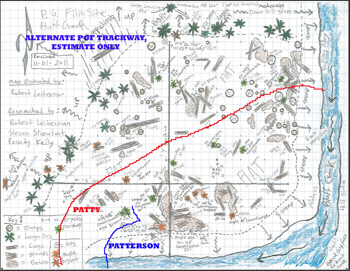
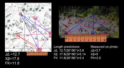
Here is an image that shows how we first started seeing with surety that we must have found the right spot, beyond just finding the "Big Trees" and some stumps.
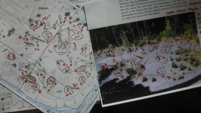
Click to Enlarge. Red lettering and map drawn by Robert Leiterman.
The mathematical proof done by an independent geologist that the site we surveyed and the "aerial" photo by Dahinden taken in 1971 are the same spot is available in the link I posted right above. We no longer have any doubts, but we look forward to other views from people like Bill Munns this summer. To be clear, what we sought in the survey were OLD FEATURES that were not part of the new growth. Almost all new trees on the nearly fully still-extant sandbar are from after the 1964 flood, and so should not have been there in 1967. We noted all of these on the map, and eliminated the rest. We noted all old-growth trees that mattered as well, knowing they were older than 44 years. This would give us, we hoped, a view of the sandbar as it was when Roger Patterson put his viewfinder upon it. Conditions today vary mainly in new trees obstructing clear view of the site. The sandbar is nearly all there as it was, save for the front or southern side, which has received some erosion due to the creek course leveling down from the higher post-flood conditions. Bob Gimlin noted this when he was there. However, the track-way and camera positions are still there.
BFBM
I certainly do not wish to violate the rules of this Forum.
Here is an image that shows how we first started seeing with surety that we must have found the right spot, beyond just finding the "Big Trees" and some stumps.
Click to Enlarge. Red lettering and map drawn by Robert Leiterman.
The mathematical proof done by an independent geologist that the site we surveyed and the "aerial" photo by Dahinden taken in 1971 are the same spot is available in the link I posted right above. We no longer have any doubts, but we look forward to other views from people like Bill Munns this summer. To be clear, what we sought in the survey were OLD FEATURES that were not part of the new growth. Almost all new trees on the nearly fully still-extant sandbar are from after the 1964 flood, and so should not have been there in 1967. We noted all of these on the map, and eliminated the rest. We noted all old-growth trees that mattered as well, knowing they were older than 44 years. This would give us, we hoped, a view of the sandbar as it was when Roger Patterson put his viewfinder upon it. Conditions today vary mainly in new trees obstructing clear view of the site. The sandbar is nearly all there as it was, save for the front or southern side, which has received some erosion due to the creek course leveling down from the higher post-flood conditions. Bob Gimlin noted this when he was there. However, the track-way and camera positions are still there.
BFBM
'Bill', on 03 Jun 2012 - 5:14 PM, said:
Steve:
Mike G was referring to the "PattyBob" stuff, which has nothing to do with my report.
Site analysis, like your excellent work, is both relevent and welcomed.
Bill
#596519The Munns Report
Posted by on 03 June 2012 - 02:53 PM
These discussions of the PGF site just above seem absolutely relevant to the work of Bill Munns, as it will help to determine many things about the film itself, its subject and trackway, and the camera lens size used to film it. Bill is going to be working on this issue this summer, so it is a vital part of the Work-in-Progress known as the Munns Report.
I'll just respond to the fellow who said above that "no one really knows where the site is" that, well, we DO know, with an incredibly high level of conviction and with evidence, where the site is. See our many YouTube videos to see how we tracked down the site, what issues and evidence and history we considered, and how we confirmed the site location in the end. See my blog in general,http://bigfootbooksblog.blogspot.com/, and perhaps this post in particular...
http://bigfootbooksb...ematically.html
Here is a search link for BLUFF CREEK FILM SITE PROJECT on YouTube, Season Two:
http://www.youtube.c...0.0.rcn36iqRe8s
Best,
BFBM
#595674The Munns Report
Posted by on 31 May 2012 - 04:44 PM
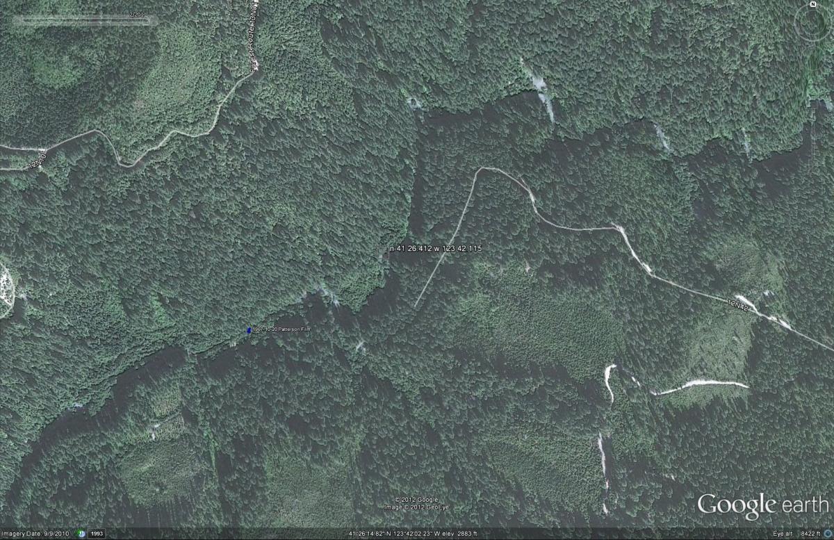
From our survey map we got this, across the creek from the first sighting spot, roughly equivalent to where we think the first frames subject was walking...
Here is the incorrect BFRO GoogleEarth location (blue pin) and ours (at first white letter)...
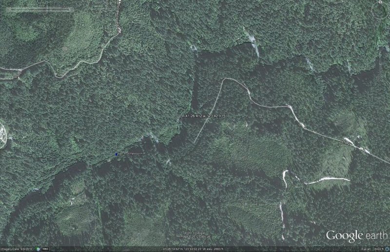
The trackway would look *roughly* like this (Bill will be able to tell better on-site, and this is just a sketch)...

Click images to enlarge.
GPS unit readings do tend to vary, so I am told, keep in mind.
Any professional survey advice before we get back up there would of course be appreciated.
BFBM

Here is the incorrect BFRO GoogleEarth location (blue pin) and ours (at first white letter)...
The trackway would look *roughly* like this (Bill will be able to tell better on-site, and this is just a sketch)...
Click images to enlarge.
GPS unit readings do tend to vary, so I am told, keep in mind.
Any professional survey advice before we get back up there would of course be appreciated.
BFBM
'xspider1', on 31 May 2012 - 2:25 PM, said:
According to this from Steve's blog:
http://bigfootbooksb...om/search?q=gps
the coordinates are about:
N 41° 26.399 W 123° 42.105
(unless that has been revised).
I looked on Google Earth and on Google maps but I didn't spot Patty yet : /
haha
#594998The Munns Report
Posted by on 29 May 2012 - 06:14 PM
Gimlin first re-identified the first sighting spot in 2003, but was not too sure of it then. The creekbed has changed somewhat, and the sandbar is covered in new trees. It seems incredible, but no one could identify the actual spot where the film subject walked, the big trees and other features, until we came along and tried to prove the true film site. We had to rule out many areas, but Gimlin's memory turned out to be totally accurate. Based upon many other factors, we were able to rule out the other proposed locations, and chose to survey the extant sandbar up the bank from Gimlin's spot. The Finding Bigfoot show did not even attempt to film on the actual sandbar, and only showed Gimlin at the sighting spot on the opposite side of the creek. Bobo's re-enactment was filmed in the creekbed, not up on the higher sandbar above, due to the need for a clear area and proper lighting for filming.
See the survey map I posted a few posts up for the current state of things. Also, we have over sixty videos on YouTube showing the whole area. Watch the last 10 or so if you want to see the actual spot as it is today.
Links to all of this, the information and videos, may be found here: http://bigfootbooksblog.blogspot.com/
A lot of the information is in this one: http://bigfootbooksb...discovered.html
BFBM
'BFSleuth', on 29 May 2012 - 10:12 AM, said:
Drew, if you go to BFROVIDEOS channel on Youtube they have several videos at the site. These aren't shot with Bob Gimlin as they aren't shot with Finding Bigfoot and I believe the one time they tried the snow was too much. TV producers need to learn that little things like weather and snow conditions play a role in production schedules. Yes, the site has changed quite a bit since 1967. The floods from the winter of 66/67 created the wide open area we see in the PGF. The flood scoured out a wide channel and many trees were sucked into the waters, creating log jams here and there on the river. Since that time trees have grown up again and I'm sure there has been a more minor flood or two. The basics of the area look familiar in the BFRO videos for anyone that has studied the PGF. And the sand and soil is medium gray. No snow white sand anywhere to be found.
#582731The Munns Report
Posted by on 20 April 2012 - 01:42 PM
Here is some info. on the Kodak cameras...
and...
"The final 16mm spool loading Cine-Kodak the K100 arrived in 1956 with both turret and non-turret versions."
from http://en.wikipedia....wiki/Cine-Kodak
You can see me with my K-100 here...
http://bigfootbooksb...s-and-ends.html
Here's a couple of samples:
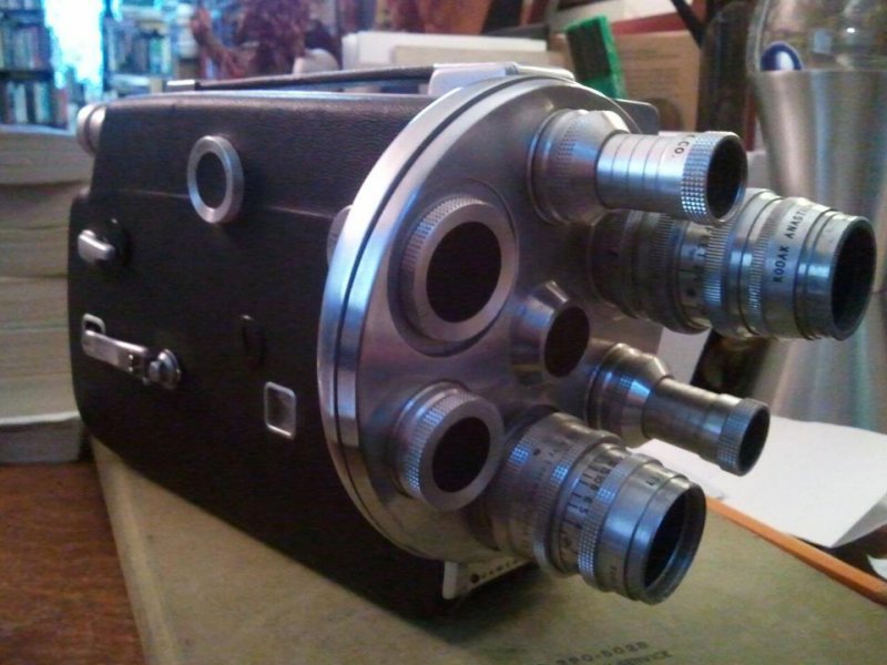
It has 25 and 50 mm lenses in the turret.
BFBM
"Kodak 16mm: Kodak 100’ Models include the following cameras, divided by film requirements: Models: A, B, BB*, E and G, made from 1923 through about 1954 use 2R only. Few are still in serious use.
Models: Cine Kodak Special (1933-1948), Cine Kodak Special II (1948-1961), Cine Kodak K-100 and Reflex Special all use 1R"
http://motion.kodak....ion/caminfo.htmand...
"The final 16mm spool loading Cine-Kodak the K100 arrived in 1956 with both turret and non-turret versions."
from http://en.wikipedia....wiki/Cine-Kodak
You can see me with my K-100 here...
http://bigfootbooksb...s-and-ends.html
Here's a couple of samples:

It has 25 and 50 mm lenses in the turret.
BFBM
#138410The Munns Report
Posted by on 30 January 2012 - 05:07 PM
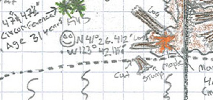
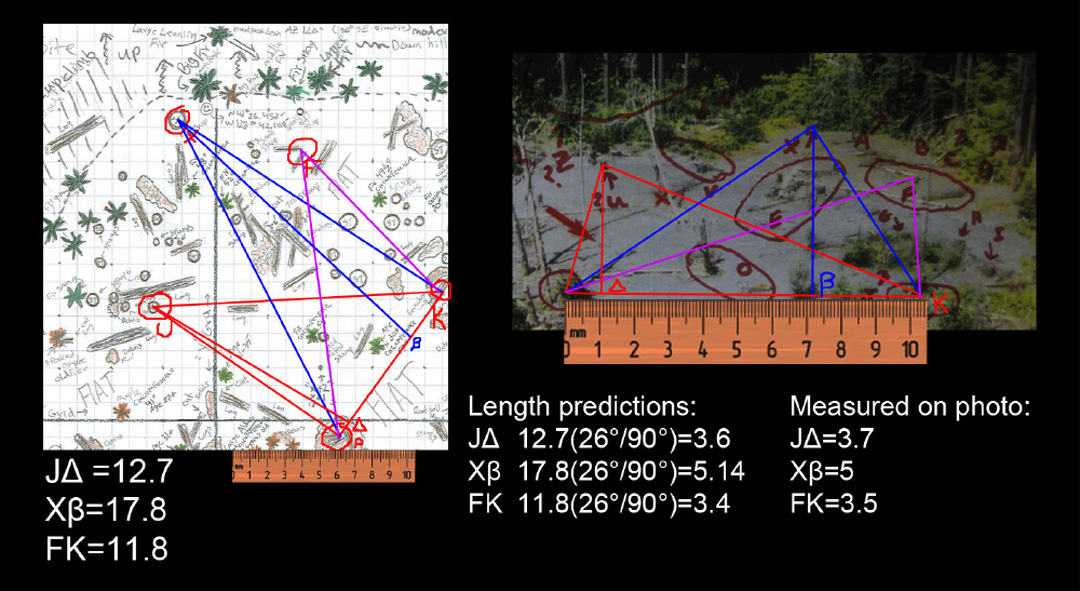
Our mathematical analysis comparing the site survey map to the 1971 aerial photograph by Dahinden not only proves the site location conclusively, but should also aid in locating the exact trackway and camera postition.
We will hopefully have a professional surveyor up there next summer to refine measurements, and it would of course be grand to have the famous Munns optical/film expertise on site.
Check out the latest analysis and information, and view our latest videos here:
http://bigfootbooksb...ematically.html
The analysis was done by a practicing geologist, using trigonometry and geometry that goes way over my English major head.
(Click image to enlarge.)
Best,
BFBM
(Steve, Bigfoot Books, Willow Creek)
http://bigfootbooksblog.blogspot.com/
'Bill', on 30 Jan 2012 - 4:10 PM, said:
zigoapex:
In the matter of the distance "Patty" walked and calculating stride, I believe we are close to finally settling that once and for all. I do need a personal site visit to wrap that up, and the prospect of that happening this year is promising at present. Walk speed however is also dependent on the camera filming speed, and we haven't yet found a way to certify the film camera's speed. So there is that obstacle to overcome.
But one thing I have found is that sometimes a new piece of evidence will unlock a previously stalled line of investigation, and make something possible which was not possible before. So I'll have to wait and see how much new evidence is obtained from the site visit. The camera speed may yet be solved. I will keep an open mind to the problem and possible solutions.
Bill
#124320The Munns Report
Posted by on 06 December 2011 - 08:08 PM
I already commented on the flora issue a while back.
With the current image on here I can see more detail. I agree it looks like holly, but it probably isn't. The red looks like a dead part of a leaf, not berries, under enlargement. The glossy leaves are interesting. There are live oaks growing sporadically up there. There are also azaleas and rhododendrons all over those hillsides. It also seems too early for holly berries in mid-late October. I have no recollection of seeing holly growing up there, over many years and wide travels up and down the creek.
The "rose" is not a rose; by any other name, it is a young madrone or a rhododendron, with dying leaves in spots. This is common for pre-winter times of the year, where these plants can lose "superfluous" leaves or branches, prioritizing for the ones that are most viable under low-moisture summer conditions. Wild roses around here are fairly rare, and are pinkish and whitish in color. I am no botanist, but have gotten pretty darn familiar with the flora around here and in Bluff. I don't recall holly up there. I am asking Robert Leiterman, a member of our Film Site Project who is a parks ranger, to comment. I have learned much of my Bluff Creek botany from him. It's part of his job.
The black lines on the tree are clearly the shadows of vine maples, which infest the area. It is my decided opinion that the photo was taken at Bluff Creek.
The "bucket," under this higher resolution, looks clearly like a wood chunk. Same with the other piece on the ground. And I'd say they look perfectly ordinary for the remains of a logging project. They cut out wedges when falling trees. There was salvage logging on the site in 1965-66, which included taking out some of the trees on the sandbar to clear it against potential future flooding and log jams. These stumps are still there on the site, as are old sawed off log pieces.
Louse Camp is right on Bluff Creek, but that is not Louse, as P and G were not seen there by the road construction crews based there for the building of the Blue Creek Mountain ridge road extension that summer and fall.
BFBM
#115035The Munns Report
Posted by on 31 October 2011 - 04:33 PM
We only suggested it as a possibility, Parnassus. I have not gone off the handle. Gimlin would not have been able to refer to a bridge that was not there the one time he was there before Wasson's book. However, she went up that very part of the creek with Rene, as that was the way in there in 1977. Our speculations on this matter remain reasonable. BUT yes, it is often very difficult to find solidly verifiable sources on these Bluff Creek matters. Sometimes one has to theorize. Nothing is wrong with that.
I would suggest to you, Parnassus, that you should take YOUR stuff to some other thread. Frankly, why not JREF?
"Personal stuff and ad homs"... I have no idea what you are even talking about.
In fact, I will not waste my "time and cred" even listening to you anymore.
BFBM
I would suggest to you, Parnassus, that you should take YOUR stuff to some other thread. Frankly, why not JREF?
"Personal stuff and ad homs"... I have no idea what you are even talking about.
In fact, I will not waste my "time and cred" even listening to you anymore.
BFBM
#114764The Munns Report
Posted by on 30 October 2011 - 09:24 PM
Just back from Bluff Creek. We measured all the big main tree distances. We got more GPS readings. Leiterman is camped there on the sandbar as I speak. Hopefully he won't get eaten by a cougar.
Seeing those trees today has left me with no doubt in my mind. Still, we have to prove it; and Bill is the man to do it.
More tomorrow. I promise photos.
BFBM
Seeing those trees today has left me with no doubt in my mind. Still, we have to prove it; and Bill is the man to do it.
More tomorrow. I promise photos.
BFBM
#114383The Munns Report
Posted by on 29 October 2011 - 06:37 PM
'Bill', on 29 Oct 2011 - 7:04 PM, said:
Steve:
I look forward to seeing it. Any sign of the cluster of 4-5 trees up the slope and between the Big tree and the Ladder tree? I figured that for one of the more reliable things still standing, as trees or as stumps.
If you can email me a high resolution map of your site documentation, I'd appreciate it. send to wmunns@gte.net
Photos would be wonderful too.
I'd like to compare it to my site model diagram.
Bill
Bill, the only logging done there was 1965 to 1966, salvage logging post-flood, pre-PGF. The old firs still stand, and there are indeed clusters of big firs behind there and along the subsequent background area. It is not easy to get a proper photograph due to new growth obscuring and also destroying the possibility of gaining perspective. I may be able to get up there tomorrow to check. It would be very helpful to have the images of the trees you've done showing them with clarity. I'd be happy to send all the data to you in a cooperative spirit. What would help us greatly is at least a clip section of your frame by frame scans of the film to sort out camera perspectives during the film as the view shifts among the old stumps and in relation to the big trees. In our grid I can see where I think cameraman and subject walked, but it is difficult to establish perspective orientation of our map to the actual film as seen mainly in Frame 352 and the documentation of it done by Dahinden, Green, and Byrne. Using the aerial photo requires a radical shifting of viewpoint. We hope your expertise will enable us to establish facts, distinguished from perceptual suppositions and perspective illusions. At this point we are finding the Murphy site model insufficient, and perhaps inaccurate.
Parnassus, you mean Louse CAMP, right? Well, the road there went right along the creek just up a bit on the hillside as it does today. Then it descended slightly to creek level where it headed left upstream or right up to the ridge. McClarin and Henry drove this route in 1967, as did many locals over the years. The old Bluff Creek Road heads up the creek from around Fish Lake to and past Louse Camp, all the way past the film site three miles past the bridge. What is your issue, aside from a large need for the thrill of schadenfreude?
BFBM
#114368The Munns Report
Posted by on 29 October 2011 - 05:31 PM
'parnassus', on 29 Oct 2011 - 3:17 PM, said:
Stop trying to use Dahinden for this. Wasson doesn't say that her source is Dahinden, does she? In fact, it appears that her source for that section of the book is Gimlin. Wouldn't u agree? Its just another version of Gimlin's same story. So trying to drag Dahinden into this is not warranted; it's wishful thinking and it's deceptive. tsk tsk.
And that pretty well blows up your suggestion of Dahinden rebar marking the campsite. Not to mention the fact that nobody else seems to have been able to drive north along the creek bottom from the vicinity of Louse Creek.
When Gimlin was there there was in fact no bridge over Bluff Creek at that spot, so it could not have been he who told that to Wasson. However, she went to the site with Dahinden in 1977 while she was researching her book. It could only have been he, and in fact she is said to have been "involved" with Rene at the time. Another arrogant fail, Mr Parnassus.
Bill, we have almost certainly gained proof of the location of the true PGF site. We have found the big tree, with a maple beside it, a fir beside that, followed by a spiky younger fir snag, and a dead ringer for the ladder tree, with other firs following that match well. We have gridded out the entire sandbar, and have a map showing all major old stumps and wood debris piles. All seem to match very well. We'd like to have your professional opinion of the site map we have produced. I'll post a lower resolution version here soon. We have all measurement data for you, on a north to south axis from Gimlin's first sighting spot. The north line runs directly to the big trees spot. Features are plotted within ten yard squares on the grid. This should be enough to prove it out once camera perspective is established.
BFBM
#111033The Munns Report
Posted by on 20 October 2011 - 04:30 PM
My post has a lot to do with this thread, namely identifying the spots depicted in Roll One of the Patterson footage, which Bill Munns has rediscovered and scanned and presented here.
There was doubt expressed as to whether the packhorse footage was shot in the Bluff Creek bottom. Well, I can with near 100% certainty say that it indeed is. If that isn't Bluff Creek to you, then I simply don't know what I can say. Much of it is extremely familiar to me, and also essentially identical to the scenery seen in the Bigfoot parts. Hence, Bill's work serves once again to confirm the veracity of much in the PGF accounts given by Patterson and Gimlin.
If you want to police this thread, perhaps you should ask Mr. Munns first if it needs it, eh?
I am talking about film that Munns has been studying, so I really don't know how to make Parnassus happy. Perhaps nothing will, short of an ape suit.
BFBM
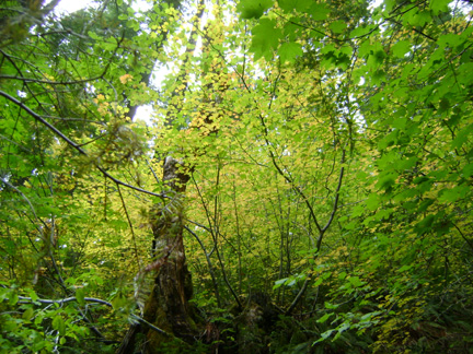
Here is Bluff Creek, from October 12th. This is the vine maple foliage still yellow, with nary a reddish tinge found on the PGF site.

Here are some old sawn stumps and rotting logs found on the upper sandbar, near the big trees, PGF site, Oct. 12th this year. We believe these are those seen in the film.
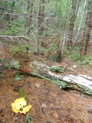
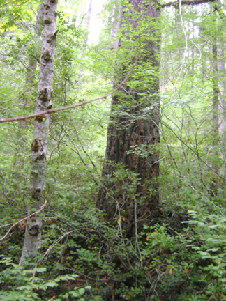
Here is one of the best prospects for the "Big Tree," found near those stumps.

There was doubt expressed as to whether the packhorse footage was shot in the Bluff Creek bottom. Well, I can with near 100% certainty say that it indeed is. If that isn't Bluff Creek to you, then I simply don't know what I can say. Much of it is extremely familiar to me, and also essentially identical to the scenery seen in the Bigfoot parts. Hence, Bill's work serves once again to confirm the veracity of much in the PGF accounts given by Patterson and Gimlin.
If you want to police this thread, perhaps you should ask Mr. Munns first if it needs it, eh?
I am talking about film that Munns has been studying, so I really don't know how to make Parnassus happy. Perhaps nothing will, short of an ape suit.
BFBM
Here is Bluff Creek, from October 12th. This is the vine maple foliage still yellow, with nary a reddish tinge found on the PGF site.
Here are some old sawn stumps and rotting logs found on the upper sandbar, near the big trees, PGF site, Oct. 12th this year. We believe these are those seen in the film.
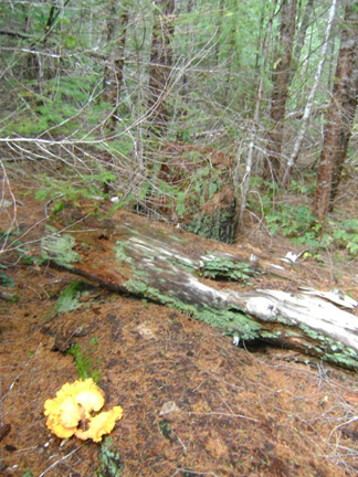
Here is one of the best prospects for the "Big Tree," found near those stumps.